Thank you! Your submission has been received!
Oops! Something went wrong while submitting the form.

Thank you! Your submission has been received!
Oops! Something went wrong while submitting the form.
Thank you! Your submission has been received!
Oops! Something went wrong while submitting the form.


Thank you! Your submission has been received!
Oops! Something went wrong while submitting the form.
Solutions

WHO WE SERVE
Use cases
Technology
Resources
DATA DRIVEN OPTIMIZATION
Improve ROI by optimizing usage and efficiency
Zeelo's data-led routing cuts waste and boosts utilization

Boost your program efficiency
Demand-based routing, right-sized vehicles, and schedules aligned to real usage reduce cost per rider
Compare your routes VS where people actually live
Visualize different lists of addresses on a map and compare clusters VS the location of your current stops
Identify public transit gaps at different times of day
Public transit coverage changes throughout the day, we help identify these gaps
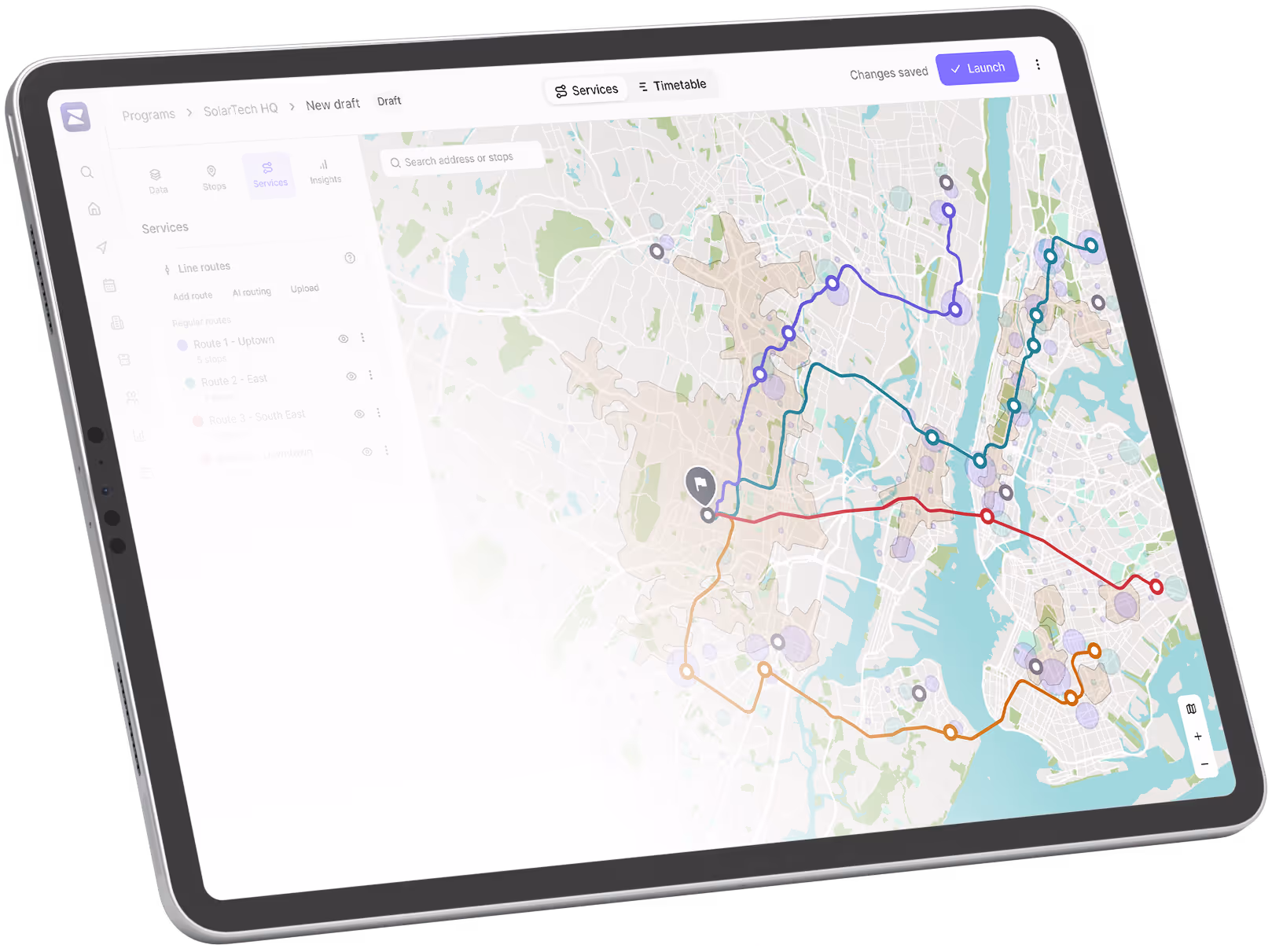
AI routing engine optimizes vehicle VS length
AI will automatically connect pickup locations using the shortest routes, with as few vehicle as possible
Stop requests, Purchases and Address searches all visible on a map
Understand where to expand your program based on previously unknown demand
Data driven decision making
Comprehensive reporting to help you make informed choices
Our comprehensive reporting will easily let you assess the health of your transportation programs. Your dedicated account manager will help you make informed decision to further improve your shuttle program.
Utilization & Ridership
Track current and forecasted shuttle usage to optimize capacity.
Sustainability Insights
Measure environmental impact and track carbon savings.
Route & Schedule History
Monitor route and timetable changes with performance impact analysis.
Heatmap Analysis
Visualize current users, stops requests and areas of high demand on a map to decide where to expand or refocus your routes.
Rider Behavior
Analyze rider retention, trip frequency, and engagement trends.
Stop Request
Identify new stop demand with detailed request location data.
Rider Feedback & Ratings
Collect and analyze trip ratings and rider feedback for service improvement.
Customer Care Reporting
Track support inquiries, common complaints, and resolution times.
Boarding Compliance
Report on riders who missed bookings or boarded without valid reservations.
ROI Analysis
Evaluate cost-per-rider and optimize spending efficiency.
SLA Performance
Monitor adherence to Service Level Agreements and operational benchmarks.
Operator Spend Management
Track and manage costs when working with external operators.
Book a call now to explore our transportation solutions
A transportation expert will explore how our solutions can help you with your unique challenges
Frequently asked questions
How do you design the most efficient routes?
We analyse anonymized rider location data, demand density, and travel patterns to create optimised routes that minimise travel time while maximizing vehicle occupancy.
How do you adapt routes as demand changes?
Our system continuously monitors ridership and booking patterns, allowing routes, stop locations, and schedules to be adjusted as demand evolves over time.
How do you determine the right number and size of vehicles?
We use historical and real-time usage data to match vehicle size and fleet allocation to actual demand, reducing empty seats and avoiding overcrowding.
Can you serve areas with limited public transport?
We identify underserved areas using geographic and demand data, then design routes that connect riders efficiently to key destinations or transportation hubs.
How do you measure and improve performance over time?
We track key metrics like occupancy, travel time, and on-time performance, and use these insights to continuously refine routes and improve efficiency.

Trusted. Every trip.
Zeelo is the smart bus platform for organizations. We design, manage and optimize transport programs to help our clients achieve their goals.